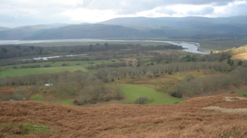
Ynys Hir is a internationally recognized landscape situated along the southern edge of the Dyfi Estuary in Ceredigion, Mid Wales. It sits within the UNESCO Dyfi Biosphere, serving as a critical ecological bridge between coastal saltmarshes and oak woodlands.
- How Did the RSPB Establish the Ynys Hir Nature Reserve?
- Which Key Wildlife Species Depend on the Ynys Hir Ecosystem?
- What Visitor Trails and Facilities Are Available at RSPB Ynys Hir?
- How Does Ynys Hir Contribute to Regional Culinary and Economic Tourism?
- What Environmental Challenges Threaten the Future of Ynys Hir?
- Frequently Asked Questions
Ynys Hir sits six miles southwest of Machynlleth and thirteen miles north of Aberystwyth. The area encompasses 800 hectares of diverse topography. Its position along the River Dyfi creates an estuarine boundary where tidal saltwater meets freshwater streams running off the Cambrian Mountains. The geographical features include ancient sessile oak canopy cover, lowland peat bogs, tidal mudflats, and grazed saltmarsh. This mosaic of microclimates supports high levels of biodiversity within a small footprint.
The topography consists of low-lying ridges that protrude into the estuarine floodplain. These elevated rock formations provided safe dry land for early settlement, trade, and agriculture. The surrounding tidal mudflats host complex biological networks driven by the incoming and outgoing tides. The local hydrology keeps the peatlands saturated throughout the year, preserving soil carbon and preventing land degradation. Regional weather patterns deliver regular rainfall, maintaining the lush green foliage and temperate rainforest conditions native to Mid Wales.
The location is a focal point for environmental researchers and conservation bodies. It serves as a natural barrier against coastal erosion by absorbing high tides and seasonal river discharges from the Dyfi basin. The balance between marine environments and terrestrial forest zones establishes Ynys Hir as a key geological and ecological asset in the county of Ceredigion.
How Did the RSPB Establish the Ynys Hir Nature Reserve?
The Royal Society for the Protection of Birds purchased the Ynys Hir land in 1969 to preserve its unique wetland and woodland ecosystems. The acquisition protected the area from agricultural drainage, industrial forestry, and coastal development threats.
The land at Ynys Hir had a long history of human land use before its conservation purchase. During the eighteenth and nineteenth centuries, local timber was felled for charcoal production to support regional lead smelting furnaces. Traditional farming practices grazed cattle on the saltmarshes, shaping the ground structure for specific bird species. By the mid-twentieth century, land consolidation threatened to destroy native plant life through potential land reclamation and conifer planting.
The RSPB recognized the site’s habitat diversity and designated it as a protected reserve. Conservation management shifted toward habitat restoration, including water table management and selective invasive species removal. The reserve gained international status as part of the Ramsar wetland network, a Site of Special Scientific Interest, and a Special Protection Area. Between 2011 and 2013, the site gained national attention when it hosted the flagship BBC Springwatch television series.
Habitat management protocols maintain distinct ecological zones within the reserve boundaries. Conservation teams control water levels in artificial pools to provide breeding sites for amphibians and wetland birds. Controlled cattle grazing continues on the saltmarsh to keep vegetation at optimal heights for nesting waders. Today, the reserve stands as an exemplary model of habitat restoration, combining conservation science with controlled public access to protect vulnerable UK wildlife.
Which Key Wildlife Species Depend on the Ynys Hir Ecosystem?
Ynys Hir supports over two hundred recorded bird species, rare invertebrates, and mammals that depend on its protected habitats. The reserve provides critical wintering grounds, nesting territories, and feeding stops along major migratory flyways.
The woodland zones host breeding populations of pied flycatchers, wood warblers, and redstarts during the spring and summer months. These summer migrants utilize nest boxes installed throughout the oak forest canopy. Birds of prey patrol the skies year round, including red kites, peregrine falcons, merlins, and hen harriers hunting across the open marshland. The dead timber within the ancient oak woods provides essential habitat for specialized beetles and fungi species.
The wet grasslands and estuarine mudflats attract breeding lapwings and redshanks in summer. During winter, thousands of migratory waterfowl arrive from northern Europe and Greenland. Species include teals, wigeons, pintails, shelducks, and the only regular wintering flock of Greenland white-fronted geese in England and Wales. Examples of mammals active across the reserve include Eurasian otters, water voles, and several species of bats that roost in older trees.
The saltmarsh and bog areas support specialized plant species such as sundews, bog asphodel, and marsh orchid. Invertebrate life flourishes in the unpolluted waters, providing ample food for resident fish and bird life. The seasonal changes alter the species composition constantly, making the reserve an active ecological laboratory year round. The continuous protection of these food chains ensures long-term species survival in Mid Wales.
What Visitor Trails and Facilities Are Available at RSPB Ynys Hir?
RSPB Ynys Hir offers maintained walking trails, observation hides, a visitor center, and accessible facilities designed for birdwatching and educational visits. The infrastructure balances public visitor enjoyment with minimum disturbance to sensitive wildlife zones.
The visitor center is located near the main entrance off the A487 road at Eglwys-fach. The facility provides detailed visitor maps, recent wildlife sighting boards, light refreshments, and retail items. Parking is available on site, including dedicated bays for mobility badge holders. Path networks radiate from the visitor center, guiding walkers through seven distinct hides strategically positioned across woodland, freshwater pool, and estuary habitats.
Trail options vary in length and terrain difficulty to accommodate different fitness levels. The Trail features level boardwalk paths suitable for pushchairs and limited mobility access near the visitor center. The longer Estuary Trail crosses uneven terrain, leading visitors past oak woods out to views of the Dyfi Estuary mudflats. Educational panels along the routes explain habitat management, historical land use, and species identification tips.
Observation hides feature openable viewing slots, bench seating, and species guide charts to help visitors identify birds. Strict rules prohibit domestic dogs on the trails to prevent disturbance to ground-nesting birds and grazing livestock, though registered assistance dogs are permitted. Entrance fees apply to non-RSPB members, directly funding habitat conservation and trail maintenance work across the property.
How Does Ynys Hir Contribute to Regional Culinary and Economic Tourism?
Ynys Hir drives high-value regional tourism through world-class hospitality, combining ecological heritage with destination dining. The adjacent Michelin-starred restaurant brings international visitors, supporting the rural economy of Ceredigion and Powys.

The estate adjacent to the nature reserve holds historical significance as a former country house, once used as a retreat by Queen newport/victoria/">Victoria’s household. In modern times, this property transformed into Ynyshir Restaurant and Rooms, led by executive chef Gareth Ward. The establishment became the first restaurant in Wales to hold two Michelin stars, attracting global food enthusiasts to this remote valley. This culinary draw produces a spillover economic effect for local accommodation providers, transportation services, and regional suppliers.
The business model relies on showcasing local Welsh ingredients, including aged Welsh Wagyu beef and regional seafood. The presence of a premier dining destination alongside a premier nature reserve creates a unique luxury tourism pairing. Visitors routinely combine nature walks along the Dyfi Estuary with destination dining, increasing overall tourist spend within the local area.
This economic activity creates skilled jobs in hospitality, land management, and eco-tourism within rural Mid Wales. The international reputation of the area reinforces regional identity, highlighting Ceredigion as a destination for quality, sustainability, and unique natural assets. The integration of commercial success and nature preservation serves as a sustainable template for rural economic development.
What Environmental Challenges Threaten the Future of Ynys Hir?
Climate change, sea-level rise, coastal flooding, and invasive species present major ongoing risks to the long-term integrity of Ynys Hir. Conservation managers implement adaptive strategies to mitigate land loss and ecological degradation.
Rising sea levels along the Cardigan Bay coastline increase the frequency of salt water flooding into freshwater habitats. High tide surges erode the soft saltmarsh edge, gradually shrinking the available breeding ground for waders like lapwings. Increased salt concentrations in soil and freshwater pools can disrupt plant communities and reduce insect populations critical for migratory bird diets. Conservation teams build bunds and sluice gates to control water salinity levels dynamically.
Shifting weather patterns cause extreme rainfall events, resulting in localized flooding from freshwater streams coming down off adjacent hills. Conversely, extended summer droughts lower the groundwater table, drying out peat bogs and releasing stored carbon into the atmosphere. Managing water volume requires active engineering, including controlled flooding regimes and ditch clearance work.
Invasive non-native plants like Rhododendron ponticum and Himalayan balsam threaten native oak woodlands by blocking light and crowding out forest floor species. Eradication programs require continuous physical labor and chemical treatments to prevent spread. Continuous environmental monitoring ensures conservation management adapts quickly to climate realities, preserving Ynys Hir for future generations.
Frequently Asked Questions
What is the best time of year to visit Ynys Hir nature reserve?
Spring and winter offer the best wildlife viewing experiences at Ynys Hir. Spring brings returning migratory songbirds like pied flycatchers to the oak woods. Winter brings thousands of migratory ducks, geese, and birds of prey to the Dyfi Estuary.
Can you bring dogs to RSPB Ynys Hir?
Pet dogs are not allowed on any trails at RSPB Ynys Hir to protect ground-nesting birds and livestock. Registered assistance dogs are the only exception and may accompany visitors on trails.
How far is Ynys Hir from Aberystwyth and Machynlleth?
Ynys Hir is located approximately six miles southwest of Machynlleth and thirteen miles north of Aberystwyth off the A487. The drive takes roughly ten minutes from Machynlleth and twenty minutes from Aberystwyth.
Is there parking available on site at Ynys Hir?
Yes, a dedicated visitor car park is available at the reserve entrance near Eglwys-fach. Parking is free for RSPB members, while non-members pay a small entry fee covering parking and trail access.