")

Bronington captivates with its rural charm and borderland heritage, Nestled in the serene countryside of Wrexham County Borough. This unassuming village offers a peaceful escape near the England-Wales divide, perfect for those seeking authentic Welsh history and natural beauty.
Origins and Etymology of Bronington
Bronington’s name traces back to 1284, recorded as “Bronynton,” hinting at Anglo-Saxon roots with “ingtun” meaning a settlement associated with a person named Bron or similar. This suggests early habitation before the Norman Conquest, though definitive proof remains elusive as new place names emerged post-1066. The village evolved within the vast ecclesiastical parish of Hanmer, functioning as a township until 1836 when it gained its own parish status, also known as New Fenns.
Historians note that medieval records are sparse, pointing to Bronington as a probable manor with dispersed farms rather than a centralized hub. By the 18th century, enclosure maps from 1777 reveal just nine buildings around a central green south of modern School Lane, termed Brannington Green in earlier accounts. This green, now infilled with contemporary homes, marked the nucleus of growth, transitioning from scattered crofts to a recognizable village only in the 20th century.
Geographical Setting and Landscape
Situated southwest of Whitchurch in Shropshire, Bronington lies along a minor road west of the A495 Ellesmere-Whitchurch route, about six kilometers from the main thoroughfare. Its low-lying, level terrain borders the expansive peat mosses of Fenn’s and Whixall, less than two kilometers south, shaping a landscape of fertile fields and mossy expanses.
The village’s position in Maelor Saesneg, an English-speaking historic area within Wales, underscores its border dynamics. Proximity to the Shropshire line influences its cultural blend, with easy access to English market towns while rooted in Welsh administration under Wrexham County Borough. This setting fosters a rural idyll, where peatlands support unique biodiversity and agriculture dominates the economy.
Government records from Vision of Britain describe it encompassing 4,850 acres in the 19th century, with real property valued at £3,908 and a population of 675 across 145 houses, highlighting its agrarian scale. Today, the terrain remains predominantly agricultural, with mosses preserved as Sites of Special Scientific Interest for their ecological value.
Historical Evolution Through the Centuries
Bronington’s development from the 13th to 18th centuries shows a dispersed pattern of farms and cottages, lacking a church until the 19th century. John Evans’ 1795 map omits it as a named settlement, instead labeling the area Fenns Heath with housing along moss edges. The 19th century saw expansion along School Lane, with outlying farms like New Hall and Bay Tree emerging prominently.
Enclosure transformed open commons into defined fields, spurring building along key lanes. Ordnance Survey maps from 1829 first formally recognize Bronington as a settlement focus, though nucleation solidified later. The 20th century brought modernization, filling the historic green and adding amenities, yet preserving its rural essence amid Wrexham’s growth.
Academic insights into Maelor’s historic landscape character emphasize Bronze Age activity remnants and medieval field systems, with Bronington exemplifying post-medieval farmstead evolution in Higher Lanes. This progression reflects broader Welsh border patterns, balancing isolation with connectivity to regional trade.
Religious and Community Foundations
Prior to 1836, residents worshipped in Hanmer’s parish church, reflecting Bronington’s township status. The new Holy Trinity parish addressed growing needs, supported by patrons like Sir J. Hanmer, with the vicarage valued at £109 in older records. The church’s modest design—barn conversion with later expansions—mirrors practical rural faith.
Community life revolved around this site, fostering vicarage ties and events. School Lane’s development paralleled church influence, naming suggesting early educational roots. Today, the church remains a focal point for services and gatherings.
Economic Life and Agriculture
Agriculture defines Bronington’s economy, leveraging fertile moss-edge soils for dairy, crops, and peat-related pursuits historically. 19th-century township stats show divided property among few owners, sustaining smallholder farming. Enclosure boosted productivity, with farms like New Hall and Bay Tree exemplifying prosperous holdings.
Peat mosses provided fuel and litter until industrialization, now valued for conservation. Modern diversification includes tourism, with walking trails through Fenn’s and Whixall Mosses drawing nature enthusiasts. Wrexham’s rural policies support sustainable farming, preserving Bronington’s agrarian character.
Local businesses cluster modestly, serving daily needs amid commuter links to Wrexham and Whitchurch. This balance sustains population stability around historic levels.
Natural Environment and Wildlife
Bronington’s proximity to Fenn’s and Whixall Mosses—among Britain’s largest lowland mires—enriches its ecology. These SSSIs host rare bog species, sphagnum mosses, and birds like hen harriers and bitterns. Boardwalks enable exploration, blending recreation with habitat protection.
Fields yield wildflowers and insects, supporting pollinators vital to farms. Water management prevents flooding, maintaining peat integrity against climate shifts. Community stewardship enhances biodiversity, with trails linking village to mosses.
Cultural Identity and Border Influences
In Maelor Saesneg, Bronington embodies English-Maelsor heritage, historically Welsh March lands under English sway post-Norman times. Flintshire ties pre-1974 placed it administratively in England-like zones, shifting to Wrexham in 1996. This duality fosters a hybrid culture: English dialects prevail, yet Welsh civic pride endures.
Festivals and markets echo border traditions, with Whitchurch proximity aiding cross-border ties. The village community council preserves identity via heritage projects.
Modern Community and Amenities
Bronington’s community thrives via the council at bronington-cc.org, managing events and planning. A primary school on School Lane serves young families, alongside a pub and village hall for social hubs. Sports clubs and WI groups knit fabric, emphasizing rural resilience.
Housing mixes historic cottages with new builds, accommodating growth without urban sprawl. Broadband improvements support remote work, attracting families.
Architectural Heritage and Notable Buildings
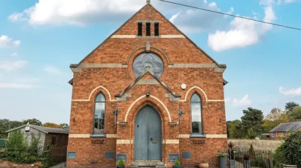
The village’s built heritage centers on 17th- and 18th-century structures. Glenmoor and Breen Cottages stand as the oldest in the core, both brick-built from the 1700s, alongside a timber-framed barn at Pear Tree House and elements at Post Office Farm. Outlying gems include Maesllwyn House with its 17th-century brick house and barn, New Hall Farm’s partially rebuilt 17th-century core, and early 18th-century Malt Kiln farmhouse.
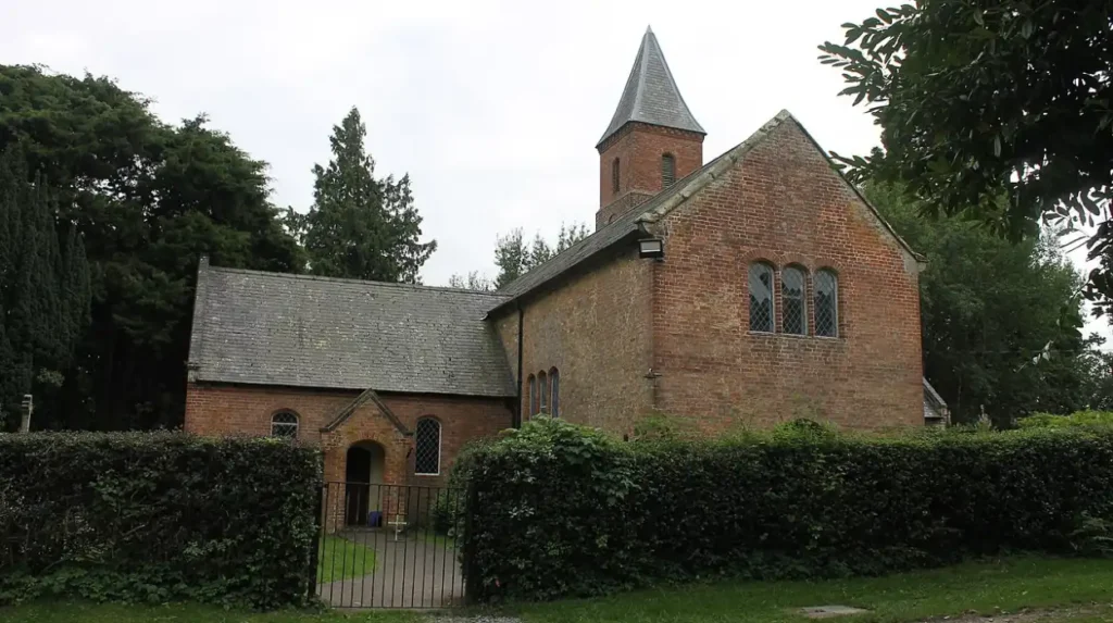
Holy Trinity Church, dedicated in 1836, originated as a converted barn with transepts added, a small tower in 1864. Detached southeast of the village near the vicarage, it anchors spiritual life. Most other buildings date to the 19th and 20th centuries, blending seamlessly into the landscape without grand estates dominating.
These structures embody vernacular architecture suited to peatland farming: sturdy brick and timber frames resisting damp conditions. Preservation efforts by local councils highlight their role in maintaining Bronington’s historic integrity.
Attractions and Visitor Experiences
Explore Holy Trinity’s architecture or hike moss trails for sundews and dragonflies. Cycle the A495 or visit nearby Overton for history. Farms offer seasonal vistas, ideal for photography.
Whitchurch’s markets provide day-trip allure, five miles east. Bronington suits quiet retreats, with B&Bs emerging for overnights.
Bronington in Broader Welsh Context
As Wrexham microcosm, Bronington exemplifies preserved rurality amid regional revival. Its mosses contribute to national peat restoration, aligning with Welsh green goals. Border status enriches Wales’ diverse tapestry, from industrial north to pastoral south.
Future prospects hinge on sustainable tourism and farming, ensuring timeless appeal.
Preserving Bronington’s Future
Local efforts combat development pressures, prioritizing heritage listings and eco-projects. Community engagement via council initiatives secures legacy for generations. In Wrexham’s dynamic borough, Bronington endures as a verdant haven.
This village, with roots over 700 years deep, invites discovery of Wales’ understated borderscape. Its story of quiet evolution resonates eternally.