Borth y Gest North Wales is a coastal village situated on the northern edge of the Glaslyn estuary within the county of Gwynedd. The settlement sits exactly one mile south of the harbor town of Porthmadog on the Llŷn Peninsula boundary.
- What Is the Historical Significance of Borth y Gest?
- What Are the Main Beaches and Natural Features of the Village?
- How Can Travelers Walk the Wales Coast Path Route Here?
- What Birdwatching and Wildlife Opportunities Exist in the Estuary?
- What Panoramic Viewpoints Can Visitors Experience?
- What Are the Essential Safety and Practical Visitor Guidelines?
- FAQs About Borth y Gest North Wales
- What is the best way to get from Porthmadog to Borth y Gest?
- Can you walk from Borth y Gest to Black Rock Sands at high tide?
- Are dogs allowed on Borth y Gest beaches during the summer?
- Is there free parking available anywhere in Borth y Gest village?
- What are the best food options or places to eat in Borth y Gest?
The village occupies a distinct horseshoe-shaped bay where the Afon Glaslyn completes its journey from the mountains of Eryri National Park to the Irish Sea. This specific geographic positioning creates a sheltered microclimate that protects the immediate shoreline from prevailing Atlantic winds. Administratively, the community falls under the jurisdiction of Gwynedd Council and represents a vital conservation zone within the designated Aberglaslyn Site of Special Scientific Interest. The coordinates of the village center register at grid reference SH565375, placing it directly along the maritime frontier of Cardigan Bay.
The surrounding topography features the prominent volcanic crag of Moel y Gest, which rises to an elevation of 263 meters immediately northwest of the houses. This geological formation provides a structural barrier that isolates the settlement from the busier commercial corridors of the A487 trunk road. The shoreline transitions from a muddy inner harbor where maritime vessels moor at low tide to a series of secluded sandy coves further west. These ecological zones host distinct saltmarsh vegetation and ancient oak woodlands that line the cliffs, contributing to the high environmental value of the regional landscape.
What Is the Historical Significance of Borth y Gest?
The history of Borth y Gest centers on its ancient role as the primary marine crossing point over the dangerous Traeth Mawr estuary. Before nineteenth-century industrialization, local guides operated from this settlement to navigate travelers across treacherous tidal quicksands.
Prior to the year 1811, the geography of the region looked completely different because the sea advanced deep into the valleys towards Tremadog. The residents of the village earned their livelihood by guiding horses and carriages across the shifting sands of the estuary toward Harlech uk/local/swansea/castle/">Castle on the southern bank. This occupation required precise knowledge of the daily tidal schedules as the incoming waters claimed numerous lives throughout the century. The construction of the Porthmadog Cob embankment in 1811 by William Madocks permanently altered the local economy by land-reclaiming the estuary and ending the ferry business.
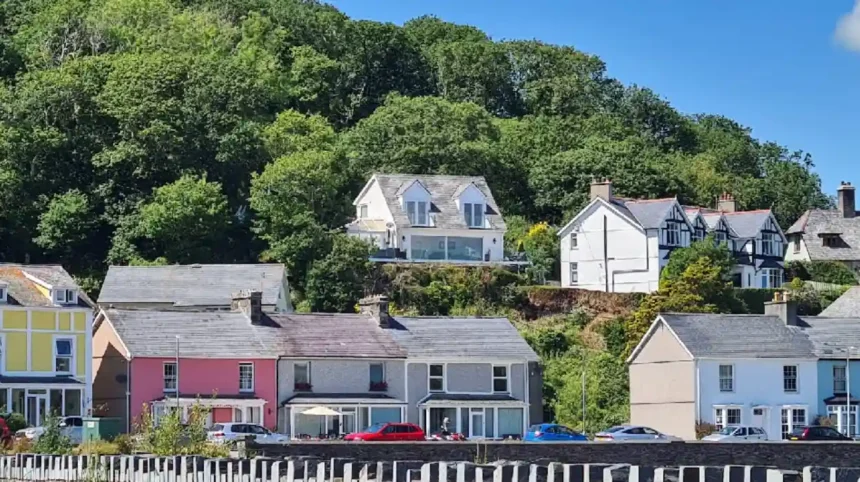
Following the loss of the estuary crossing trade, the settlement transitioned into a small shipbuilding hub and pilot boat station during the mid-nineteenth century. The deep-water channel allowed small wooden schooners to deliver slate from the quarries of Blaenau Ffestiniog before the development of Porthmadog harbor. The current architecture of the village reflects the subsequent Victorian tourism boom that occurred between 1870 and 1900. Wealthy industrial entrepreneurs built the neat rows of pastel-colored terraced cottages along Mersey Street to serve as elegant summer residences, preserving a distinct architectural aesthetic that remains entirely intact today.
What Are the Main Beaches and Natural Features of the Village?
The coastal landscape consists of a sequence of sandy coves accessible via a cliffside path extending westward from the harbor. These public locations include Borth y Gest Beach, Bay Nest, Parrot Cove, and the tidal headland of Ynys Cyngar.
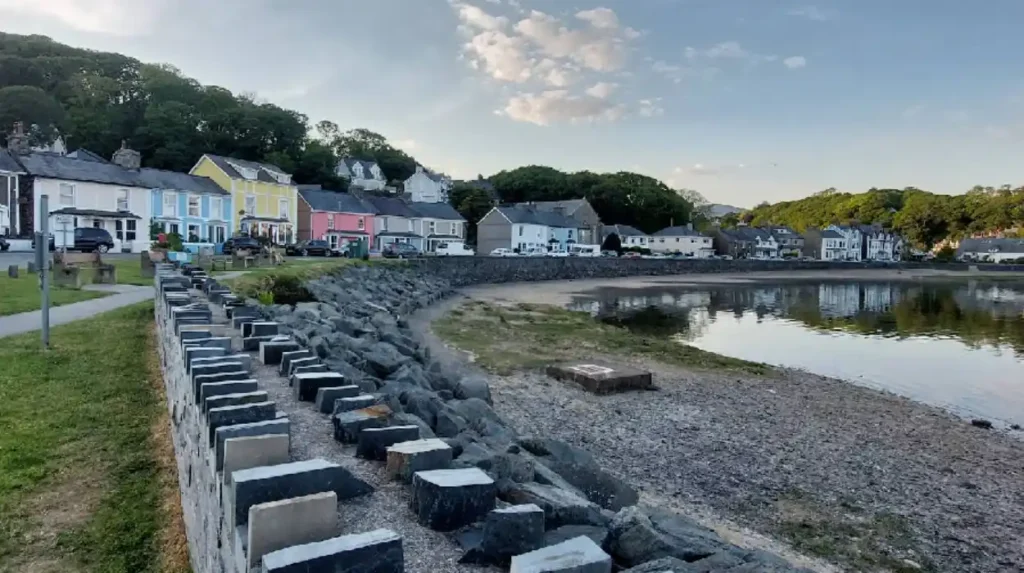
The primary harbor beach consists of mixed sand and silt where local sailboats rest on the seabed during low tide periods. Walking westward along the designated path reveals a series of pristine pocket beaches composed of fine golden sand and framed by dark rock formations. The first major cove is Bay Nest, followed immediately by the secluded sands of Parrot Cove, both of which face south toward the estuary. These locations feature significant displays of green, yellow, and white crustose lichens covering the coastal rocky outcrops.
The sequence terminates at Ynys Cyngar, a rocky headland that functioned as a separate tidal island before coastal siltation connected it to the mainland. The waters around this point exhibit complex tidal currents because the combined outflow of the Glaslyn and Dwyryd rivers merges with the incoming tide of Cardigan Bay. Beyond this headland, the coastline opens up into the expansive three-mile sandy stretch of Black Rock Sands at Morfa Bychan. The intertidal zones across these locations support diverse marine biology, with seasonal sightings of leatherback turtles, harbor porpoises, and grey seals in the deeper channels.
How Can Travelers Walk the Wales Coast Path Route Here?
The walk from the village car park to Ynys Cyngar covers a distance of two kilometers along a clearly waymarked coastal path. The route utilizes a gravel and tarmac track that accommodates families, strollers, and intermediate walking enthusiasts.
The journey begins at the municipal car park situated directly opposite the village seafront. Walkers must follow the distinctive blue and yellow signs of the Wales Coast Path heading west past the historic terraced cottages. The first section of the path features a smooth, paved gradient that leads to an interactive augmented reality panel managed by the Wales Coast Path authority. This digital installation allows visitors to use mobile applications to explore the maritime history and biological records of the Glaslyn estuary.
The path transitions into a well-maintained gravel track that undulates gently along the contours of the low cliffs. Multiple short flights of stone stairs provide direct access down to the individual sandy coves along the route. The terrain requires sturdy footwear because the final approach to the Ynys Cyngar headland involves walking directly over loose sand and uneven rock terrain. The walking trail can be extended by continuing two additional miles across Black Rock Sands, forming a circular four-mile loop that returns inland through the Porthmadog Golf Club links.
What Birdwatching and Wildlife Opportunities Exist in the Estuary?
The mudflats and saltmarshes of the Glaslyn estuary provide a critical habitat for thousands of resident and migratory bird species. The location ranks as a premier birdwatching destination in Gwynedd due to the immense feeding grounds exposed daily.
During the spring and summer breeding seasons, the estuary attracts significant populations of wading birds and marine feeding species. Visitors can regularly observe oystercatchers, redshanks, and curlews utilizing their specialized bills to extract invertebrates from the exposed intertidal mudflats. The summer months bring large nesting flocks of sandwich terns that plunge-dive into the river channels to capture small sand eels. The nearby Bywyd Gwyllt Glaslyn Osprey Project, located three miles inland, means these rare birds of prey frequently forage for fish directly in front of the village.
The ecological dynamic shifts during the autumn and winter periods when arctic migratory waterfowl arrive in the shelter of the bay. The open waters host wintering populations of goldeneyes, great crested grebes, wigeons, and teal that escape freezing northern latitudes. The saltmarsh vegetation, dominated by sea purslane and cordgrass, offers essential high-tide roosting sites for these birds. The optimal viewing times occur two hours on either side of low tide, when the expansive sandbanks become fully accessible to the feeding flocks.
What Panoramic Viewpoints Can Visitors Experience?
The geographic alignment of the village offers an uninterrupted panorama across the sea to medieval Harlech Castle and the mountain ranges. The vistas combine coastal architecture, marine estuaries, and high-altitude peaks within a single visual frame.

Marcus Oakland
Looking directly southeast across the Traeth Bach expanse reveals the imposing stone silhouette of Harlech Castle perched on a sheer rocky crag. King Edward I founded this fortress in the year 1283, and it remains a dominant historical landmark visible from almost every coastal path viewpoint. To the left of the castle, the heavily wooded peninsula of Portmeirion Village appears along the shoreline. This Italianate settlement, designed by architect Sir William Clough-Williams between 1925 and 1975, displays a colorful contrast against the dark green native oak woodlands.
Turning further east brings the dramatic mountain topography of the Rhinogs into view, with rugged summits rising abruptly past 2000 feet. The sharp peak of Cnicht, frequently referred to as the Matterhorn of Wales due to its symmetrical profile, stands out clearly in the northeast sky. This alignment allows observers to track the path of the Afon Glaslyn as it flows past the historic shipping routes of Porthmadog. The visual quality changes hourly with the shifting Welsh tides, transforming from a vast watery plain to an intricate network of shining river channels cutting through golden sandbanks.
What Are the Essential Safety and Practical Visitor Guidelines?
Visiting the shoreline requires strict adherence to local maritime safety notices, RNLI guidelines, and parking regulations. The extreme tidal range of Cardigan Bay creates fast-moving water hazards that can trap uneducated coastal visitors.
The primary hazard involves the rapid incoming tide, which can isolate walkers exploring the rocks around Ynys Cyngar. The Royal National Lifeboat Institution installs explicit red warning signage detailing the specific safety hazards of each beach section. Visitors must check the daily Porthmadog tide tables before entering the intertidal zones because the water depth changes by several meters within a short time frame. Swimming is strictly discouraged within the main river channels due to the severe undertows and undercurrents caused by the converging river outflows.
Practical infrastructure includes a pay-and-display car park located at the eastern edge of the bay, which fills to capacity during peak summer months. Public transport links connect via the mainline railway station in Porthmadog, which serves the Cambrian Coast Line and the heritage Ffestiniog Railway. The village maintains a public toilet block and dog-restriction zones on specific sections of the inner beach between May and September. Visitors traveling with pets should utilize the westernmost coves, which remain open to dogs throughout the calendar year.
Related Article: Navigating regional infrastructure safely is key to exploring the coast. See how North Wales travel experts share live bank holiday road conditions before you set off on your next trip.
FAQs About Borth y Gest North Wales
What is the best way to get from Porthmadog to Borth y Gest?
You can easily walk from Porthmadog to Borth y Gest along a flat, scenic coastal path that takes about fifteen to twenty minutes. Alternatively, a regular local bus service connects the two locations, or you can drive via the local road network in under five minutes.
Can you walk from Borth y Gest to Black Rock Sands at high tide?
Walking along the beach from Borth y Gest to Black Rock Sands is impossible during high tide as the water completely covers the rocky headlands and coves. To make this journey safely when the tide is in, you must use the inland public footpaths that cut past the local golf course.
Are dogs allowed on Borth y Gest beaches during the summer?
Gwynedd Council enforces seasonal dog restrictions on the main harbor beach directly in front of the village from May to September. However, the secluded sandy coves further along the coastal path toward Ynys Cyngar remain completely dog-friendly throughout the entire year.
Is there free parking available anywhere in Borth y Gest village?
Free parking is extremely limited to a few designated on-street spaces along the seafront, which fill up quickly early in the day. Visitors generally need to use the main pay-and-display municipal car park located at the entrance of the village.
What are the best food options or places to eat in Borth y Gest?
The village features a few highly rated independent establishments located directly on the waterfront, including a popular licensed bistro and a traditional tea room. These spots are well-known for serving locally sourced Welsh seafood, homemade cakes, and barista coffee with panoramic views of the estuary.