Dinas Cross is a linear village, an administrative community, and a former ecclesiastical parish located within the Pembrokeshire Coast National Park in West Wales. The settlement occupies a coastal platform on the northern edge of the Mynydd Dinas and Mynydd Carningli volcanic massif, positioned along the primary A487 road exactly midway between the coastal towns of Fishguard and uk/local/newport/">Newport. The community encompasses a total geographic area of 14.42 square kilometers and maintains a recorded population of 875 residents according to the 2024 demographic estimates. This community territory includes the central linear settlement along with two distinct coastal hamlets, which are named Cwm-yr-Eglwys and Pwllgwaelod. The local governance operates via an elected community council, while the broader electoral boundaries fell under the Newport and Dinas ward for Pembrokeshire County Council representation starting in the 2022 local elections.
- What historical events shaped the architecture and community of the village?
- What are the main natural attractions and coastal landmarks to visit?
- How do hikers navigate the Dinas Island loop trail?
- What local amenities and infrastructure support sustainable tourism?
- What are the archaeological profiles of the nearby ancient monuments?
- Frequently Asked Questions
- What happened to the old church at Cwm-yr-Eglwys near Dinas Cross?
- Is Dinas Island near Dinas Cross actually a real island?
- What public transportation options serve Dinas Cross village?
- Where can visitors find automotive fuel and parking in Dinas Cross?
- Are there any prehistoric or ancient sites located near Dinas Cross?
The underlying bedrock geology of the region consists of Ordovician slates and complex volcanic rock formations. The surface topography features significant Quaternary period Pleistocene glacial and peri-glacial deposits that shape the rolling agricultural landscape. A notable geological feature is the low-lying valley separating the mainland from Dinas Island, which was formed as a glacial meltwater channel during the last ice age. The natural environment is strictly managed under national park guidelines to protect diverse marine and terrestrial habitats. These habitats include rocky shores, sandy beaches, maritime cliffs, and lowland mixed deciduous woodlands. The village sits within the traditional boundaries of the ancient Hundred of Cemais, appearing on historic regional maps dating as far back as 1578.
What historical events shaped the architecture and community of the village?
The architectural landscape and cultural identity of the village reflect a rich maritime history defined by nineteenth-century sea captains and catastrophic weather events. During the early nineteenth century, the parish recorded a stable population of 741 inhabitants, many of whom found employment in maritime trade, agriculture, and seasonal herring fishing. Prosperous sea captains constructed numerous traditional stone-built cottages and detached houses that remain visible along the primary linear thoroughfare today. The educational infrastructure expanded significantly in 1869 when local stonemason James Williams constructed the village school, known as Yr Hen Ysgol, for a total sum of 347 British pounds. This historic structure has been preserved and serves the community as the primary civic center and public hall. Religious worship has deep roots in the locality, originating from the fifth-century missionary work of Saint Brynach the Abbot. Nonconformist religious expansion later resulted in the construction of several chapels, including Tabor Baptist Chapel, Gideon Independent Chapel, and the now-disused Ramah Methodist Chapel.
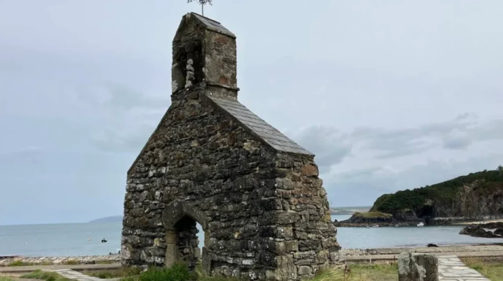
The defining historical catalyst for the community occurred between October 25 and October 26 in the year 1859, when the Royal Charter Storm struck the Irish Sea. This extreme meteorological event, which caused more than 800 fatalities across the United Kingdom, completely compromised the original parish church of Saint Brynach situated at the shoreline of Cwm-yr-Eglwys. The heavy seas completely destroyed the roof, the nave, and the northern wall of the medieval structure, leaving only the western end wall and the belfry standing. In the year 1880, authorities demolished the remaining loose ruins to facilitate the engineering of a continuous defensive stone seawall to protect the immediate valley. A replacement parish church was completed higher up in the safety of the main village between 1860 and 1861. The area also links to international military history, as Pencnwc Farm within the community was the birthplace of Sergeant William Batine James, who emigrated to America and became the only recorded Welshman to die at the Battle of the Little Bighorn in 1876.
What are the main natural attractions and coastal landmarks to visit?
The primary natural attractions within the community boundary are centered around the prominent peninsula known as Dinas Island, which rises to a maximum elevation of 125 meters above ordnance datum. This headland features dramatic vertical cliffs, rugged maritime slopes, and expansive views across Newport Bay to the northeast and Fishguard Bay to the southwest. The perimeter of the headland is accessible via the Pembrokeshire Coast Path, a designated national trail that attracts thousands of long-distance hikers annually. The peninsula itself remains an active agricultural landscape managed via traditional farming methods on the historic Dinas Island Farm, with large sections of the coastal fringe under the protective ownership of the National Trust. Wildlife enthusiasts regularly observe diverse seabird colonies, including razorbills, guillemots, and fulmars, nesting on the sheer rock faces during the spring breeding season. The surrounding waters are also part of a protected marine conservation zone where Atlantic grey seals and harbor porpoises are frequently sighted.
The two coastal hamlets flanking the peninsula offer contrasting marine environments and recreational opportunities for visitors. Cwm-yr-Eglwys features a sheltered, east-facing sandy cove that provides a safe anchorage for small watercraft, dinghy sailing, and family recreation. The iconic ruins of the medieval Saint Brynach church sit immediately adjacent to this beach, providing a stark visual reminder of coastal erosion and maritime history. On the western side of the headland lies Pwllgwaelod, a dark sand beach flanked by rugged cliffs that faces southwest into Fishguard Bay. A flat, low-lying footpath measuring approximately one kilometer in length connects these two hamlets through the sea-level valley, utilizing the ancient glacial meltwater channel to provide an accessible walking route that avoids the steep climb over the headland. Inland, the landscape transitions into the historic Hescwm Mill, a beautifully restored medieval watermill situated 200 meters from the coast that is officially designated as a Grade II* listed building due to its architectural integrity.
How do hikers navigate the Dinas Island loop trail?
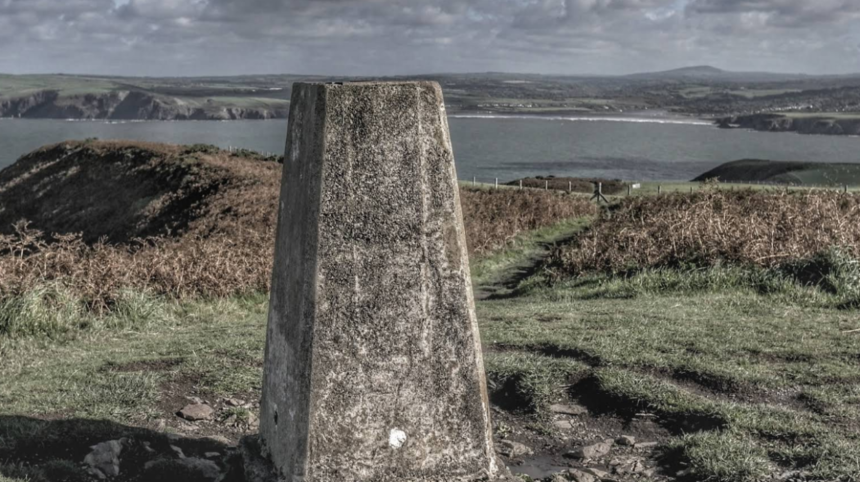
Navigating the Dinas Island loop trail requires an understanding of the specific terrain, elevation changes, and access points that characterize this popular circular walking route. The standard trail measures approximately 5.13 kilometers in total length and typically commences at the public automotive parking area located immediately adjacent to the beach at Pwllgwaelod. From this starting point, hikers ascend a steep, well-defined clay and crushed stone path that climbs northward along the western cliff edge of the headland. The trail demands appropriate footwear and physical fitness, as walkers experience an overall cumulative elevation gain of approximately 140 meters over the course of the trek. The path hugs the maritime cliff edge, where wooden kissing gates and clear directional signage bearing the acorn emblem of the National Trail system guide walkers safely along the route. The highest geographical point of the walk is marked by a concrete triangulation pillar erected by the Ordnance Survey, offering unobstructed panoramic views of the Preseli Hills landscape.
The descent phase of the loop trail trends southeastward toward the sheltered inlet of Cwm-yr-Eglwys, where the grade becomes gentler and passes through coastal gorse and bracken habitats. Upon reaching the sea wall at Cwm-yr-Eglwys, walkers inspect the historic church ruins before initiating the final return segment of the journey. This concluding section utilizes the level, sea-level valley path that cuts directly west across the neck of the peninsula to link back to Pwllgwaelod without further climbing. The entire circular route requires an average of two hours to complete at a moderate walking pace, though adverse weather conditions can significantly increase the difficulty and duration. The trail is fully integrated into the regional public transport network via the Poppit Rocket coastal bus service, which operates under the route number 405 to connect the trailheads to broader transportation hubs.
What local amenities and infrastructure support sustainable tourism?
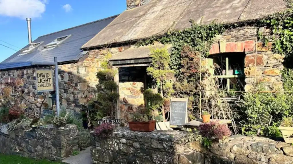
The infrastructure of the village combines essential commercial amenities, traditional hospitality establishments, and sustainable transport initiatives designed to support both residents and seasonal visitors. The linear settlement along the A487 road features a core group of businesses, including an active automotive service station that supplies the closest public fuel distribution point to the neighboring town of Newport. Retail needs are met by a well-stocked local convenience store, a traditional fish and chip takeaway shop, and a part-time post office operating within the community hub. Hospitality is distributed across four distinct public houses and restaurants that possess long operational histories within the parish boundary. These traditional establishments include The Ship Aground and The Freemasons Arms situated within the main village, alongside The Old Sailors restaurant located directly on the beachfront at Pwllgwaelod. Cultural tourism is further supported by independent art spaces open to the general public, specifically the Coast and Wild studio found on Feidr Fawr and the David Light Gallery located at Myrtle Hill.
Sustainable tourism management within the Pembrokeshire Coast National Park is facilitated by dedicated infrastructure designed to minimize private vehicular impact on the fragile coastal environment. The local authority maintains public car parks at both Pwllgwaelod and Cwm-yr-Eglwys, which feature integrated waste management facilities and educational signage detailing local ecological bylaws. The Poppit Rocket bus service allows hikers to access specific sections of the Pembrokeshire Coast Path without relying on personal vehicles, thereby reducing traffic congestion on the narrow, stone-walled rural lanes. The community hall at Yr Hen Ysgol serves as an information node, hosting regional heritage displays, local craft exhibitions, and environmental awareness meetings. This balance of commercial utility and conservation framework ensures the long-term preservation of the unique West Wales coastal landscape.
What are the archaeological profiles of the nearby ancient monuments?
The archaeological landscape immediately surrounding the village contains significant prehistoric monuments that indicate continuous human occupation dating back to the Neolithic period. The most prominent archaeological site in the immediate vicinity is the Cerrig y Gof chambered tomb, a scheduled ancient monument situated near the eastern boundary of the community toward Newport. This prehistoric burial structure consists of five distinct megalithic chambers arranged in a unique, rough circular formation that measures approximately 16 meters in diameter. Archaeological excavations have revealed that these chambers were constructed using large local volcanic stones, originally covered by a substantial mound of earth and smaller stones known as a cairn. The architectural layout of Cerrig y Gof represents a rare variant of the portal dolmen tradition, which specialized antiquarian researchers link directly to Atlantic fringe burial practices observed across western Britain and Ireland.
The wider landscape features several isolated prehistoric standing stones, stone alignments, and low earthwork enclosures distributed across the lower slopes of Mynydd Dinas. These monuments are officially included within the boundary of the Newport and Carningli Registered Landscape of Special Historic Interest, a designation that recognizes the profound cultural and ritual connections between the coastal plateau and the high ridges of the Preseli Hills. The placement of these megalithic features suggests they served multiple societal functions, including territorial markers, ancestral commemoration sites, and astronomical alignments for early agrarian communities. The preservation of these sites is monitored under Welsh heritage frameworks, ensuring that modern agricultural practices do not compromise the integrity of these ancient features.
Related Articles For Further Reading
- Coastal Property Analysis: Explore the evolving structural landscape of traditional regional properties in our deep dive into the Holiday Cottages Market Dynamics.
- Welsh Destination Profiles: Expand your knowledge of premier coastal staycation hubs with the Glan Gwna Holiday Destination Guide.
Frequently Asked Questions
What happened to the old church at Cwm-yr-Eglwys near Dinas Cross?
The medieval church of Saint Brynach the Abbot was severely damaged by the catastrophic Royal Charter Storm on October 25 and 26 in the year 1859. The extreme waves destroyed the roof and the main walls, leaving only the western end wall and belfry standing today. A protective stone seawall was subsequently built in 1880 to stabilize the ruins and protect the surrounding low-lying valley.
Is Dinas Island near Dinas Cross actually a real island?
Dinas Island is not a true island but rather a prominent peninsula that is connected to the Welsh mainland by a low-lying valley. This connecting valley was formed during the Pleistocene epoch by a substantial glacial meltwater channel during the last ice age. The headland is surrounded by water on three sides, facing Newport Bay to the east and Fishguard Bay to the west.
What public transportation options serve Dinas Cross village?
The village is directly served by the 405 Poppit Rocket coastal bus service, which runs regularly between the larger towns of Fishguard and Cardigan. This specialized public transport service stops at key points throughout the linear village and provides hikers with direct access to various trailheads along the Pembrokeshire Coast Path.
Where can visitors find automotive fuel and parking in Dinas Cross?
Automotive fuel is available at the central service station located on the main A487 road, which provides the closest fuel pumps to the town of Newport. Public parking facilities are maintained by the local authorities at the beachfront locations of Pwllgwaelod and Cwm-yr-Eglwys, both of which include direct access to the coastal paths.
Are there any prehistoric or ancient sites located near Dinas Cross?
The area features several ancient monuments, including the notable Cerrig y Gof chambered tomb which consists of five Neolithic burial chambers arranged in a circle. The village is also situated within the Newport and Carningli Registered Landscape of Special Historic Interest due to its numerous standing stones and prehistoric earthworks.