Prince of Wales Road Norwich is a major thoroughfare located in the city centre of Norwich, Norfolk, England. Built in the late nineteenth century, it connects Norwich railway station directly to the historic Market Place, uk/local/swansea/castle/">Castle, and Cathedral quarter.
- Why Was Prince of Wales Road Built in Norwich?
- What Role Does Prince of Wales Road Play in Norwich Nightlife?
- How Has the Business Landscape of Prince of Wales Road Changed?
- What Are the Transport Connections Along Prince of Wales Road?
- What Architectural Landmarks Are Located on Prince of Wales Road?
- How Is Property and Development Evolving on Prince of Wales Road?
- Frequently Asked Questions
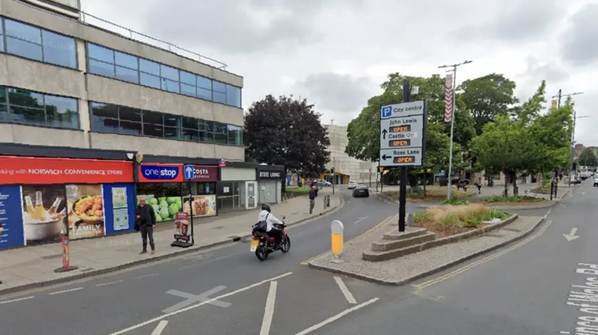
Prince of Wales Road forms a vital infrastructural axis within the central area of Norwich. The road runs in an east-west direction, commencing at Foundry Bridge on the River Wensum in the east and terminating at Agricultural Hall Plain in the west. It spans a distance of approximately 450 metres and serves as a principal access route for vehicular and pedestrian traffic traveling from the primary railway station toward the core commercial districts. Surrounding streets include Rose Lane, King Street, and Thorpe Road. The street sits within the official city center conservation boundary governed by Norwich City Council. Geographically, it establishes a direct connection between the transportation hubs along the river and the historic civic center. Its spatial positioning makes it a highly visible and heavily utilized corridor for commuters, residents, and visitors daily.
Historically, the route was constructed to modernize transit connections within the city during the Victorian era. Urban planners designed the street to bypass narrow, winding medieval lanes that previously impeded the movement of goods and passengers from the station. The layout features a wide, straight design lined with historic late Victorian and early Edwardian architecture. Many buildings along the route possess listed status, reflecting significant historic value and architectural craftsmanship. The ground floor premises primarily house commercial enterprises, including hospitality venues, professional service firms, and retail units. The upper floors increasingly consist of converted residential apartments and student accommodation. Functionally, Prince of Wales Road operates as a dual-purpose environment, catering to daytime commercial operations and acting as a primary night-time economy hub for the region.
Why Was Prince of Wales Road Built in Norwich?
Prince of Wales Road was constructed in 1862 to create a direct, modern connection between Norwich railway station and the city centre. City leaders designed the boulevard to support economic growth and accommodate increasing passenger transport demands.
During the mid-nineteenth century, Norwich experienced rapid industrial growth and an expansion of its railway transport network. The opening of Thorpe Station created an urgent requirement for a direct, wide road capable of handling heavy horse-drawn and pedestrian traffic moving into the commercial heart of the city. Prior to its construction, visitors had to navigate narrow medieval streets such as Rose Lane and King Street. Local authorities and civic planners acquired land, demolished existing structures, and engineered a boulevard-style thoroughfare. The development was named in honor of the future King Edward VII, who held the title of Prince of Wales at the time. The street was deliberately engineered wide to project civic pride and facilitate seamless commercial movement across the urban area.
The creation of the road transformed local land values and accelerated commercial development along its alignment. Banks, hotels, insurance firms, and retail establishments quickly erected substantial stone and brick premises along both sides of the street. The architectural styles reflected Victorian prosperity, utilizing ornate terracotta, Norfolk red brick, and stone dressings. Tramlines were subsequently installed along the route in the late nineteenth century, further cementing its status as a vital public transit artery. The street successfully integrated the newly established railway infrastructure into the historical economic framework of Norwich. Today, the initial layout continues to govern the flow of transit between the eastern transport terminals and the central business district.
What Role Does Prince of Wales Road Play in Norwich Nightlife?

Prince of Wales Road serves as the primary epicenter of the night-time economy in Norwich. The street features a high concentration of licensed premises, including nightclubs, late-night bars, pubs, takeaways, and entertainment venues.
The concentration of late-night venues along Prince of Wales Road makes it a dominant destination for regional nightlife. Dozens of licensed premises operate along the 450-metre stretch, drawing thousands of visitors every weekend. Venues range from large multi-room nightclubs to independent bars, traditional pubs, and international eatery locations. The high density of entertainment options creates a centralized leisure zone that operates predominantly between eight in the evening and four in the morning. Venue operators coordinate with local licensing authorities to manage capacity, security, and patron entry. The street benefits from its direct proximity to Norwich railway station and major taxi ranks, allowing visitors easy entry and exit during late hours.
Managing the high volume of late-night visitors requires coordinated public safety and policing strategies. Norfolk Constabulary operates dedicated nighttime safety patrols along Prince of Wales Road to ensure public order and prevent alcohol-related incidents. Local initiatives, such as the SOS Bus, deploy trained medical personnel and volunteers to provide welfare support directly on the street. Street marshals, CCTV surveillance, and door supervision teams operate continuously during operational peak hours. City planners and local business associations work together through the Norwich Business Improvement District to maintain cleanliness and safety along the corridor. The economic output generated by these venues contributes significantly to the hospitality sector of the local economy.
How Has the Business Landscape of Prince of Wales Road Changed?
The business landscape of Prince of Wales Road transitioned from nineteenth-century financial and commercial offices to a mixed-use district. Today, the street balances late-night hospitality, professional services, converted residential flats, and independent retail.
Throughout the late nineteenth and early twentieth centuries, Prince of Wales Road operated as a prestigious address for corporate offices, insurance companies, and legal firms. Prominent structures, such as the former Royal Insurance Building and various banking halls, anchored the professional profile of the street. Over time, commercial office requirements shifted toward purpose-built business parks outside the city centre. This structural economic change led to the conversion of former office spaces into entertainment venues, late-night food outlets, and leisure facilities during the late twentieth century. The ground-floor commercial frontage adapted to meet the demands of consumer leisure and hospitality services.
In recent years, the business landscape has experienced another significant diversification through urban regeneration initiatives. Property developers have increasingly converted vacant upper-floor commercial spaces into high-density residential apartments and student housing units. This shift toward mixed-use planning has reintroduced a permanent residential population to the street. Professional service providers, including recruitment agencies, technology firms, and creative studios, continue to occupy ground and first-floor commercial units. The street maintains a functional split between daytime professional operations and evening leisure activities. This structural evolution reflects broader urban development trends seen across regional cities in the United Kingdom.
What Are the Transport Connections Along Prince of Wales Road?
Prince of Wales Road acts as a crucial transport corridor connecting Norwich railway station to central bus routes, arterial roads, and pedestrian networks. It accommodates major bus services, taxi ranks, cycle lanes, and heavy pedestrian traffic daily.
Transport infrastructure on Prince of Wales Road is engineered to facilitate seamless multi-modal transit across Norwich. At its eastern foot, Foundry Bridge crosses the River Wensum, leading directly to Norwich railway station, which provides direct train links to London Liverpool Street, Cambridge, and regional coastal towns. Multiple local and regional bus routes transit along the street, connecting suburban residential areas to the city core. Dedicated taxi ranks operate at key intervals along the road, serving as essential infrastructure for late-night transit. Pedestrian pavements are wide, providing ample space for heavy footfall during commuter peak hours and weekend evenings.
Urban transport policies have progressively modified the street layout to improve traffic flow and pedestrian safety. Local transport authorities have introduced designated cycle lanes, bus priority measures, and signalized pedestrian crossings along the corridor. Traffic management schemes restrict certain heavy vehicular movements during specific hours to reduce congestion and carbon emissions in the central zone. The road forms an integral segment of the wider Norwich transport strategy, which emphasizes sustainable mobility and reduced urban congestion. Its position as a gateway street ensures it remains a primary focal point for ongoing regional transport planning and infrastructure investment.
What Architectural Landmarks Are Located on Prince of Wales Road?
Prince of Wales Road features prominent Victorian, Edwardian, and modern architectural landmarks. Notable structures include the former Royal Insurance Building, Regent House, historic bank buildings, and nearby heritage sites like the Agricultural Hall.
The architectural character of Prince of Wales Road is defined by late nineteenth-century commercial structures built during a period of civic expansion. Buildings are primarily constructed using local red brick, Portland stone, terracotta, and decorative flint work. The former Royal Insurance Building stands out due to its grand facade, ornate carvings, and historic structural detail. Regent House and adjacent Victorian blocks display detailed masonry, decorative cornices, and symmetrical window arrangements typical of the era. At the western terminus, Agricultural Hall Plain features substantial historic civic buildings, establishing a visual link to Norwich Castle and the medieval quarter.
Preserving the structural heritage of Prince of Wales Road is a priority for local planning authorities. Numerous buildings along the street are protected via Grade II listings, ensuring that alterations maintain historical integrity. Modern developments and shopfront renovations must adhere to strict conservation guidelines established by Norwich City Council. The street showcases a blend of historical craftsmanship alongside sympathetic modern infill developments. This architectural continuity provides an appealing visual corridor that reflects the transition of Norwich from an industrial regional hub into a modern commercial and cultural city.
How Is Property and Development Evolving on Prince of Wales Road?
Property along Prince of Wales Road is shifting toward residential redevelopments, student accommodation conversions, and improved commercial spaces. Development plans focus on creating a balanced, sustainable, and family-friendly urban environment.
Property investment on Prince of Wales Road has accelerated as demand for city-centre living increases. Developers are converting underutilized upper-floor commercial spaces into modern one-bedroom and two-bedroom residential apartments. The close proximity to Norwich railway station makes these residential properties highly attractive to commuters, young professionals, and university students. Landlords and property management companies have invested in structural refurbishments to upgrade building energy efficiency ratings and interior amenities. These residential conversions have increased permanent footfall, supporting daytime retail and food businesses along the street.
Local government planning policies aim to guide future development toward a balanced commercial and residential mix. The Norwich City Centre Masterplan identifies Prince of Wales Road as a key regeneration area for diversification. Future strategy focuses on reducing the reliance on late-night drinking establishments by encouraging daytime cafes, retail shops, cultural spaces, and professional services. Planned public realm improvements include enhanced street lighting, widened footpaths, urban greening projects, and upgraded street furniture. These structural enhancements are designed to transform the road into a welcoming, multi-use avenue for residents, businesses, and tourists alike.
Frequently Asked Questions
What is Prince of Wales Road in Norwich famous for?
Prince of Wales Road is primarily famous for being the central hub of nightlife in Norwich. It features a high concentration of nightclubs, late-night bars, pubs, and takeaway eateries. Additionally, it serves as the main architectural boulevard connecting Norwich railway station directly to the historic city centre.
Is Prince of Wales Road in Norwich safe at night?
Prince of Wales Road has a high safety presence during weekend nights due to dedicated police patrols, street marshals, and CCTV monitoring. Initiatives like the local SOS Bus provide welfare and medical support to visitors. Standard personal safety precautions should still be observed during peak late-night hours.
How far is Prince of Wales Road from Norwich train station?
Prince of Wales Road begins directly across from Norwich railway station, separated only by Foundry Bridge over the River Wensum. The eastern start of the street is less than a two-minute walk from the station concourse. This makes it extremely accessible for commuters and travelers arriving in the city.
Can you live on Prince of Wales Road Norwich?
Yes, there are numerous residential apartments and student accommodation units located on Prince of Wales Road. Many upper floors of historic commercial buildings have been converted into modern flats. Living here offers immediate access to transport links, local amenities, and central city attractions.
What are the parking options near Prince of Wales Road Norwich?
Multiple public parking facilities are available within short walking distance of Prince of Wales Road. Pay-and-display car parks are located on Rose Lane, cardiff/riverside/">Riverside, and Castle Quarter. Limited short-stay street parking and taxi loading bays are also situated along the road itself.