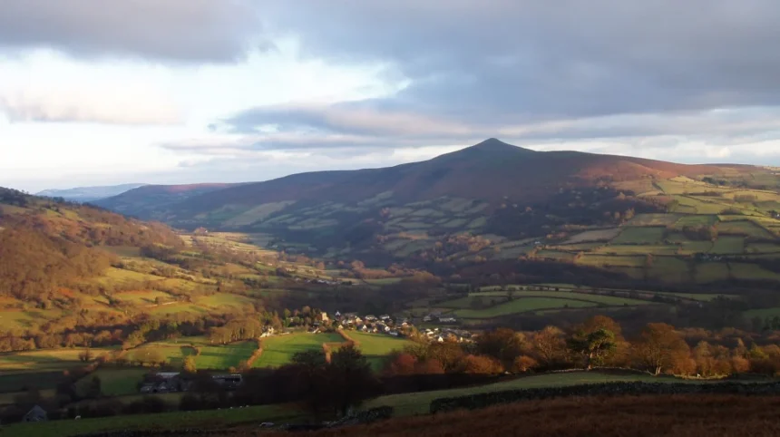
Sugarloaf Mountain Wales is a prominent peak standing at five hundred ninety-six meters above sea level within the Black Mountains range in eastern Monmouthshire. The hill dominates the skyline near the historic market town of Abergavenny. It lies inside the boundaries of Bannau Brycheiniog National Park.
The geographical coordinates place this landmark in the eastern reaches of South Wales, positioned north of the Usk Valley. The Welsh name for the mountain is Mynydd Pen-y-fal, which translates directly to mountain of the top of the peak. The summit reaches an elevation of nineteen hundred fifty-five feet, making it a recognized Marilyn landmark due to its topographic prominence relative to the surrounding terrain.
The mountain stands as the southernmost summit peak of the Black Mountains massif. Its position provides unobstructed view lines across the surrounding valleys and lowlands of the border region. The peak sits roughly three miles northwest of Abergavenny town center. The terrain covers extensive moorland, heather, and ancient oak woodland ecosystems.
The summit coordinates are registered on Ordnance Survey Landranger Map sheet one hundred sixty-one. The mountain is managed and protected by the National Trust UK charity organization. Access is granted free to the public year-round through well-maintained footpaths and designated car parks. The surrounding landscape includes three primary valley drainages, namely the Llanwenarth, Cwm Banw, and Grwyne Fechan river valleys.
How was Sugarloaf Mountain formed geologically?
Sugarloaf Mountain was formed through ancient sedimentation, tectonic uplift, and selective glacial erosion over hundreds of millions of years. The core structure consists of Old Red Sandstone and quartz conglomerate layers rather than volcanic rock. Glaciers eroded the softer surrounding rock during the last ice age.
The geological formation dates back to the Devonian period, approximately four hundred million years ago. During this geological era, massive river systems deposited layers of silt, sand, and gravel across an ancient equatorial landmass. These sedimentary deposits hardened into dense red sandstone and quartz conglomerate rock formations.
Popular local myths often attribute the symmetrical conical shape to ancient volcanic eruptions. Geological surveys confirm that no volcanic activity occurred in the creation of this peak. The distinctive conical profile is the direct result of glacial action during the Pleistocene epoch.
During the last glacial maximum, the Usk Valley glacier flowed eastward and divided into two distinct branches around the resistant sandstone mass. The glacial ice streams carved out deep channels on the northern and southern flanks of the structure. The harder quartz conglomerate at the summit resisted ice erosion, leaving a sharp peak standing above the scoured valley floors.
Subsequent post-glacial weathering caused landslips along the steep slopes of the hill. These slope failures created dramatic natural terraces and exposed underlying geological strata across the mountain sides. The combination of river sedimentation, continental uplift, and ice carving produced the modern topographical profile observed today.
What is the historical background of Sugarloaf Mountain?
Sugarloaf Mountain has a rich human history spanning prehistoric settlements, medieval agricultural grazing, and modern feminist land conservation. Archeological surveys reveal Mesolithic and Neolithic flint tool manufacturing on its lower foothills. Suffragette leader Lady Rhondda gifted the land to the National Trust in the twentieth century.
Prehistoric human activity on the mountain dates back over six thousand years to the Stone Age. Archeological excavations at Y Graig, a southern foothill, uncovered significant collections of flint tools, microliths, and scrapers. These artifacts confirm that hunter-gatherer communities utilized the elevated ridges for hunting camps during the Mesolithic, Neolithic, and Bronze Age eras.
During the Iron Age, early Celtic inhabitants constructed earthwork defenses and farming settlements on the lower slopes. Remnants of ancient field systems, trackways, and enclosures remain visible beneath the moorland vegetation today. The region became an important agricultural resource for livestock grazing throughout the Roman occupation and medieval times.
The modern English name Sugarloaf was assigned during the eighteenth century. Early topographers named the hill after its striking resemblance to the tall, conical blocks of refined sugar sold during that historical period. Similar naming conventions were applied to other sharp conical hills across Great Britain.
In nineteen thirty-eight, Margaret Haig Thomas, known as Lady Rhondda, purchased the mountain estate. Lady Rhondda was a prominent Welsh suffragette, businesswoman, and public rights advocate. She donated the peak to the National Trust to preserve public access and protect the natural landscape from industrial development.
What are the main walking routes up Sugarloaf Mountain?
The main walking routes up Sugarloaf Mountain include the popular short trail from Llanwenarth car park, the direct route from Abergavenny, and the longer circuit from Llangenny. Routes range from four kilometers to twelve kilometers in length. Paths vary in difficulty from gentle ascents to steep, rocky climbs.
The Llanwenarth car park trail represents the shortest and most accessible route to the summit. Starting at an elevation of approximately three hundred meters, this four-kilometer return trail follows a well-marked footpath through heather moorland. Hikers encounter a gradual incline before reaching a short, steep final push up the sandstone summit cone.
The Abergavenny town center trail offers a longer, more demanding hiking experience. This eight-kilometer route begins in the valley, passing through ancient oak oak woodland glades before connecting to the upper open mountain trails. The path ascends three hundred ninety meters of vertical elevation, requiring moderate physical endurance.
The Llangenny circular route approaches the peak from the western side. This ten-kilometer loop crosses the valley of Cwm Banw, ascending through forest plantations, bridleways, and open ridge tracks. It provides panoramic views of the adjacent Black Mountains peaks, including Sugar Loaf’s neighboring summits, Skirrid Fawr and Blorenge.
Each route is mapped on standard topographic hiking guides and marked by established trail signs. Navigational markers, stone pathways, and wooden gates help manage foot traffic to prevent soil erosion along sensitive moorland habitats.
What wildlife and habitats exist on Sugarloaf Mountain?
Sugarloaf Mountain hosts diverse natural habitats, including ancient sessile oak woodland, lowland heathland, acid grassland, and mountain blanket bog. These varied environments support rare flora, nesting birds, wild ponies, and specialized insect species. The wooded lower slopes are designated as a Site of Special Scientific Interest.
The lower elevation slopes feature ancient sessile oak woodlands, which have grown continuously for centuries. These forests feature a rich understory of bluebells, wood anemones, mosses, and lichens. Birch, rowan, hazel, and hawthorn trees line the stream valleys, creating protected microclimates for native animal species.
As elevation increases, woodland transitions into lowland heathland dominated by ling heather, bell heather, and gorse. Bilberry bushes cover vast stretches of the upper slopes, providing vital food resources for small mammals and birds. Acid grasslands dominate the summit area, maintaining tough grass species adapted to nutrient-poor soils.
Avian wildlife on the mountain includes predatory birds such as red kites, buzzards, and kestrels that soar over open slopes. Ground-nesting birds, including skylarks, meadow pipits, and wheatears, breed across the open heather during spring and summer months. Cuckoos are regularly heard in the oak woodlands during early summer.
Mammal populations include wild Welsh mountain ponies, red foxes, badgers, and field voles. Grazing livestock, including hill sheep and ponies, play an essential ecological role by controlling scrub growth and maintaining open heathland conditions. Rare butterflies, such as the green hairstreak, inhabit the bilberry patches across upper ridges.
What can be seen from the summit of Sugarloaf Mountain?
The summit of Sugarloaf Mountain offers panoramic three hundred sixty degree views across South Wales, Mid Wales, and western England. Clear atmospheric conditions allow visibility extending over ninety kilometers. Viewers can identify major mountain ranges, river valleys, and coastal estuaries.
Looking directly north, visitors observe the main ridge line of the Black Mountains, including the highest peak of Waun Fach. To the west, the central peaks of Bannau Brycheiniog are clearly visible, including Pen y Fan and Corn Du. The dramatic Usk Valley winds through the landscape directly below the southern slopes.
To the east, the view encompasses the Wye Valley, the Forest of Dean, and the Severn Estuary. Nearby prominent peaks, such as Skirrid Fawr and Blorenge, frame the skyline around Abergavenny. On exceptional days, the southern horizon reveals the hills of Somerset, Exmoor, and the Cotswolds across the Severn Crossing.
A concrete Ordnance Survey triangulation station, known as a trig point, marks the summit pinnacle. This trig point sits at an exact elevation of five hundred ninety-six meters, providing a focal landmark for hikers reaching the top. The exposed rock shelf at the summit consists of weather-worn quartz conglomerate beds.
The expansive sightlines made Sugarloaf an important strategic viewpoint throughout history. Today, these views attract thousands of landscape photographers, sightseers, and outdoor recreational enthusiasts annually.
Frequently Asked Questions
How hard is it to climb Sugarloaf Mountain in Wales?
Climbing Sugarloaf Mountain is considered moderate in difficulty, making it accessible for most hikers with basic fitness. The shortest trail from Llanwenarth car park takes around two hours return. The final ascent to the summit cone features a short, steep incline over rocky ground.
Can you drive up Sugarloaf Mountain?
You cannot drive to the summit of Sugarloaf Mountain, but you can drive to high-elevation car parks on its slopes. The Llanwenarth car park sits at roughly three hundred meters elevation, leaving a shorter walk to the top. Roads leading to the car parks are narrow, single-track lanes with limited parking spots.
Is Sugarloaf Mountain in Wales a volcano?
Sugarloaf Mountain is not an extinct volcano, despite its conical shape resembling one. The mountain is composed entirely of Old Red Sandstone and quartz conglomerate layers formed during the Devonian period. Glaciers carved out the surrounding valleys, leaving the hard sandstone peak intact.
Are dogs allowed on Sugarloaf Mountain Wales?
Dogs are permitted on Sugarloaf Mountain, provided they are kept under close control at all times. Free-roaming livestock, including hill sheep and wild mountain ponies, graze across the open slopes throughout the year. Dogs should be kept on short leads during spring to protect ground-nesting birds.
What is the best time of year to visit Sugarloaf Mountain?
Sugarloaf Mountain is accessible year-round, but spring and autumn offer the most pleasant conditions. Spring brings blooming wildflowers and woodland bluebells on lower paths. Autumn features striking purple heather displays across the moorland and clear, crisp conditions for high-visibility views.