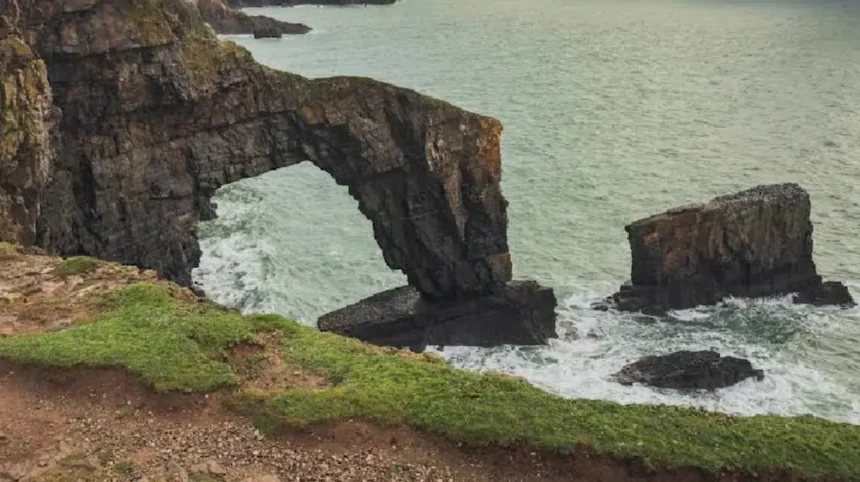
The Green Bridge of Wales is situated on the southern coastline of the Pembrokeshire Coast National Park in southwest Wales. The precise geographic coordinates place the monument within the Castlemartin peninsula in Pembrokeshire. The underlying geology consists entirely of thick Carboniferous Limestone formations dating back approximately 350 million years. This sedimentary rock layer incorporates deposits of fossilized marine organisms and chert nodules. The regional topography features steep vertical sea cliffs shaped by millions of years of marine transgression and regression.
- How did natural coastal erosion form the Green Bridge of Wales?
- What are the exact physical dimensions and structural characteristics of the rock arch?
- Why is the site located within a military training area and how does public access work?
- What ecological designations and wildlife species protect the surrounding coastline?
- How do nearby coastal landmarks such as the Elegug Stacks relate to the bridge?
- What long-term threats and storm damage impact the structural stability of the monument?
- Frequently Asked Questions
- Can visitors walk across the top of the Green Bridge of Wales?
- Why is the landmark named the Green Bridge of Wales?
- How do tourists check if the Castlemartin military firing range is open?
- What geological period created the limestone rock formations in Pembrokeshire?
- Which seabird species nest on the nearby Elegug Stacks?
The Ministry of Defence administers the surrounding land as part of the Castlemartin military training area. Public access routes connect the landmark directly to the established Pembrokeshire Coast Path network. The structural integrity of the bridge relies on the durability of the massive limestone beds exposed along this high energy coastline. Geological surveys classify the site as a prime example of differential marine erosion acting upon homogeneous soluble rock strata.
How did natural coastal erosion form the Green Bridge of Wales?
Natural coastal erosion processes sculpted the Green Bridge of Wales through continuous mechanical and chemical weathering mechanisms. Hydraulic action forces high energy waves into microscopic fractures within the vertical limestone headland. Compressed air trapped inside these rock crevices enlarges the fissures during each successive wave impact. Abrasive sand particles and suspended pebble loads act as natural cutting tools against the cliff base.
Chemical dissolution occurs as slightly acidic rainwater and seawater react with calcium carbonate minerals within the limestone. Initial wave action hollows out sea caves on opposing sides of a narrow coastal promontory. Continued erosion enlarges these subterranean chambers until they intersect completely through the rock barrier. The breakthrough creates a distinct marine arch spanning the open water gap between the severed headland and the main cliff. Subsequent gravitational collapse of weakened roof sections accelerates the transformation of arches into isolated coastal stacks.
What are the exact physical dimensions and structural characteristics of the rock arch?
The Green Bridge of Wales rises approximately 24 meters, equivalent to 80 feet, above the mean sea level. The horizontal stone span measures over 20 meters, equivalent to 66 feet, across the open channel. The eastern outer abutment rests upon a widened, highly durable rock pedestal that provides structural support. The upper horizontal surface of the stone arch features a dense covering of terrestrial grasses and coastal vegetation. Salt spray and wind exposure restrict plant species to hardy halophytic flora adapted to maritime environments. The underside of the arch exposes smooth, wave-scoured limestone surfaces scarred by historical rockfalls and structural fractures. The western anchor point merges seamlessly with the vertical mainland limestone cliffs of the Castlemartin coastline. Structural engineers and geomorphologists measure ongoing volumetric losses to quantify the rapid physical retreat of the arch. The combination of high vertical clearance and massive overhead stone weight defines its architectural classification as a natural bridge.
Why is the site located within a military training area and how does public access work?
The Green Bridge of Wales stands inside the active Castlemartin military training range owned by the Ministry of Defence. The British Army utilizes this coastal sector for live firing exercises involving armored vehicles and heavy artillery. Public access restrictions apply strictly during active firing schedules to ensure civilian safety within the impact zone. Warning flags and controlled road gates restrict vehicular and pedestrian entry during operational windows. The Ministry of Defence publishes specific firing timetables online and through local authority visitor centers. When training schedules remain inactive, the access road and adjacent coastal footpaths reopen fully for public recreation. Walkers utilizing the Pembrokeshire Coast Path must obey all posted safety notices and perimeter barrier instructions. Failure to verify range status prior to arrival results in restricted entry to the viewing platforms and surrounding coastal perimeter.
What ecological designations and wildlife species protect the surrounding coastline?
The coastline surrounding the Green Bridge of Wales holds multiple statutory conservation designations for habitat protection. The area operates as a Site of Special Scientific Interest due to exceptional geological and botanical value. European Union directives designate the marine and terrestrial zones as a Special Area of Conservation. International conservation frameworks classify the coastal strip as a Special Protection Area for breeding seabird populations. Numerous avian species utilize the sheer limestone cliffs for nesting during the spring and summer breeding seasons. Common breeding birds include razorbills, guillemots, kittiwakes, fulmars, and European shags. Terrestrial flora includes protected coastal plant species such as golden gorse, lilac heathers, and sea campion. Conservation regulations prohibit unauthorized rock climbing and habitat disturbance to safeguard vulnerable nesting colonies and rare geological formations.
How do nearby coastal landmarks such as the Elegug Stacks relate to the bridge?
The Elegug Stacks, located approximately 500 meters west of the Green Bridge of Wales, represent the next evolutionary stage of coastal erosion. These two isolated vertical limestone pillars rise roughly 25 meters directly out of the marine tidal zone. Historical geomorphological processes indicate that the Elegug Stacks were formerly coastal arches identical to the Green Bridge. Continued wave erosion eventually caused the overhead roofs of those ancestral arches to collapse completely.
The remaining seaward fragments survived as detached columns separated permanently from the mainland cliff edge. Huntsman’s Leap, another nearby geographical feature, demonstrates a collapsed cave system forming a deep vertical chasm. Comparative spatial analysis of these formations illustrates the continuous sequence of coastal retreat along the Pembrokeshire plate boundary. Each adjacent landform provides empirical evidence of the destructive mechanical forces operating continuously across the limestone shelf.
What long-term threats and storm damage impact the structural stability of the monument?
Severe meteorological events and continuous marine weathering threaten the long-term structural survival of the Green Bridge of Wales. Extreme storm surges generate hydraulic shockwaves that exploit structural weaknesses within the limestone bedding planes. In October 2017, Storm Ophelia battered the Welsh coastline and caused a significant rock volume collapse from the arch. Geomorphological experts confirm that the central stone span experiences progressive thinning from persistent wind shear and salt weathering. Climate change projections involving rising sea levels and increased storm frequency accelerate the rate of mechanical erosion.
Scientific consensus indicates that the central arch will eventually suffer total structural collapse under the weight of gravity. Following this inevitable collapse, the remaining outer abutment will transform into an isolated sea stack comparable to the Elegug Stacks. Monitoring programs utilize laser scanning technology to track micro-fractures and predict the precise timeline of structural failure.
Frequently Asked Questions
Can visitors walk across the top of the Green Bridge of Wales?
Pedestrians cannot walk across the top of the arch due to strict conservation laws and safety hazards. The fragile vegetation cover and unstable limestone surface present severe fall risks for unauthorized individuals. Visitors must observe the natural monument exclusively from designated viewing platforms situated along the perimeter path.
Why is the landmark named the Green Bridge of Wales?
The geographical feature receives its descriptive name from the thick layer of living vegetation and grasses covering its upper surface. Unlike barren rock formations found elsewhere along the coastline, this verdant top layer creates a distinct green bridge effect. The plant life survives entirely on rainwater precipitation and salt tolerant nutrients blown inland from the sea.
How do tourists check if the Castlemartin military firing range is open?
Travelers verify public access status by consulting the official Ministry of Defence firing notices published online prior to visiting. Local tourism boards and the Pembroke Visitor Centre also maintain updated schedules regarding active military training exercises. Checking these schedules ensures visitors avoid closed access roads and blocked coastal pathways during active firing periods.
What geological period created the limestone rock formations in Pembrokeshire?
The sedimentary limestone beds comprising the Pembrokeshire coastline formed during the Carboniferous period over 350 million years ago. Marine microorganisms accumulated on ancient tropical sea floors and compacted into thick layers of solid calcium carbonate rock. Subsequent tectonic plate movements uplifted these marine deposits above sea level to form the modern continental landscape.
Which seabird species nest on the nearby Elegug Stacks?
Colonies of razorbills, common guillemots, black-legged kittiwakes, and northern fulmars utilize the vertical cliff faces for annual nesting. The isolated limestone pillars provide safe nesting sites away from terrestrial mammalian predators during the vulnerable breeding months. The Welsh name Elegug derives from the traditional local terminology referencing these specific seabird populations.